


MAP QUEST
BY CRAIG LESTER • MAP COURTESY OF ALBERTA BIODIVERSITY MONITORING INSTITUTE
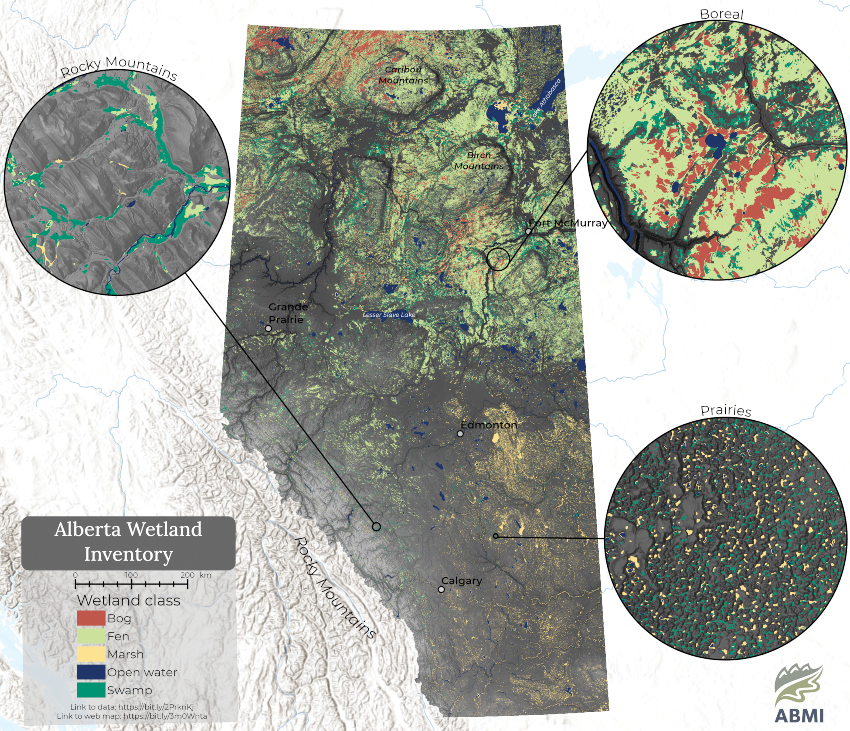
The release of the Wetland Inventory and Advanced Landcover Prediction and Habitat Assessment last spring has introduced a significant upgrade to the tracking of Alberta’s wetlands. In part, the ongoing project identifies and categorizes the province’s stock of marshes, swamps, bogs, fens and open water bodies that are 400 square metres or larger in size.
As an aid to responsible resource management and land stewardship, the Alberta Biodiversity Monitoring Institute (ABMI), headquartered at the University of Alberta, tracks changes in wildlife habitat across the province. In 2020, with the help of Alberta Environment and Parks, ABMI undertook a mapping project in an effort to improve this conservation work. At the government level, the Inventory will broadly support policy development, regional planning and allow the cumulative effects of land management decisions to be analyzed.
ABMI and Alberta Environment are now working with Ducks Unlimited Canada to ensure the project meets the province’s Inventory standards and guidelines. The monitoring process will allow the state of Alberta’s wetlands to be accurately updated on a continual basis. Further immediate improvements and updates to the Inventory are expected to be completed later this year.
Healthy wetlands play a major role in helping farmers protect their land from flooding, while they also provide habitat for many species of native and migratory birds, beneficial insects and other wildlife.
“This is the first time in 20 years the province’s wetlands count has been updated,” said Evan Delancy, ABMI spatial data science co-ordinator. Prior to the creation of this map, a sometimes inaccurate mashup of data sources was used to assess wetlands.
The web map, available for download at abmi.ca, was created with the use of radar and high-resolution optical imagery collected by the European Space Agency satellites Sentinel-1 and Sentinel-2. Wetland types appear in colour-coded chunks against a detailed satellite map. ABMI staff processed these images with the use of artificial intelligence that is able to teach itself to categorize wetlands by type and define their dimensions. The Inventory is divided into three distinct regions: the boreal and foothills, the Prairies and the Rocky Mountains.
The Inventory will assist the government with environmental monitoring and biodiversity management efforts related to agriculture. As the Inventory is available to the general public, it can be used as a tool by farmers and regional planners to identify geographic trouble spots and allow them to better plan and more easily collaborate on wetland protection and management initiatives. For example, Delancy suggested the Inventory could be used to help pinpoint pothole regions that flood regularly.
The Inventory can be used by farmers to aid in land planning, said an Alberta Environment spokesperson in an emailed statement. Water features pictured on the map should be verified on the ground, they added. This is best done in early spring when water from snowmelt is most evident. “These tools will help identify where wetlands are and should be avoided, and where there may be opportunities to restore lost or disturbed wetlands,” said the spokesperson.
Comments