


WHAT DRONES CAN AND CAN’T DO
BY EMILY JOHNSON • PHOTO: SHUTTERSTOCK
Perspective is everything and the high-flying bird’s-eye view provided by drones delivers plenty of it. Outfitted with state-of-the-art software augmented with artificial intelligence (AI) technology, drones are increasingly used for an impressive array of agricultural applications. Some of these are field ready, while others are at the research and development phase and may not be available to farmers for years. While full of promise, the use of drones in agriculture also faces hurdles, including regulatory approvals, technology lifespan and climate-related constraints.
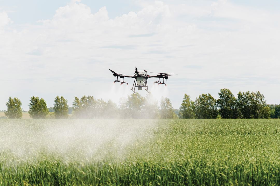
SPRAYING A WORK IN PROGRESS
Experts predict farmers may not be able to employ spray drones legally for a few more years until regulators and chemical companies complete the necessary research to support their use.
Warren Bills is vice-president of business development with Precision AI. The Regina-headquartered startup aims to employ AI-equipped drones in spray application. A regulatory barrier remains in place as crop protection products are still being tested, proven and regulated for application by drone spraying, he said. “Even though there are similar droplet sizes and water volumes used in manned aerial application equipment, there’s still not a label to support similar use in drones. If something goes wrong or if the product doesn’t work, it’s hard for the manufacturers to stand behind the product’s performance because the research is still ongoing.”
Researchers are at work to determine how drones can be used as effectively for product application as high clearance or aircraft sprayers, he emphasized. “Drift is a big concern. What we want to avoid is chemical being applied that gets drifted to the neighbour’s field, or your own for that matter, that causes more crop damage.”
Bob Hoffos, geospatial technologies (GIS/GPS) and drone instructor at Olds College shares this concern. He believes more specific data must be gathered for spray drones to overcome regulatory hurdles. “For each pesticide or herbicide that’s going to be used on a drone, we need to determine whether it poses risks to humans and the environment.
“The downwash and downwind effect are going to be affected by the speed of the drone, flying heights, nozzle locations, droplet size, environmental conditions at the time of the flight, the terrain and windspeed, among other factors,” said Hoffos. “Those are a lot of technical factors that need to be assessed and understood, and we need to build use-cases where pesticide residues on the ground are measured and overlapped.”
While research must continue, Bills is confident the current state of spray drone usage has passed the hype stage and is well into the use-case refinement cycle. “We’re seeing the adoption of these spray drones for very specific niche cases such as spraying fencelines, certain weed patches in pasture and spraying over standing waterbodies for invasive insect species.”
However, due to the Prairies’ short growing season, the seasonal research required takes time. “We have to go through the seasons and trial iterations to get proper data that supports a permitted use of a chemical,” said Bills.
Along with this regulatory challenge, the scaling up of drone use in broadacre crop production has proven to be another complex barrier to adoption. A May to September growing period leaves a small window in which researchers can test the capabilities and risk factors of spray drones. Drones have a small carrying capacity, so logistically, it’s harder to cover the acres you would with a ground unit.
Drone swarming, a co-ordinated group of units in flight together, can cover more ground faster. Precision AI employs single drones that carry a larger payload, as it is more efficient, said Bills. “With the small drones, you have to change the batteries quite often, which is just not a very fun job for anybody to have; that’s the technology barrier that we’re finding in large scale agriculture.”
LOOK DOWN ON WILDLIFE
An Agricultural Financial Services Corporation (AFSC) pilot project that focused on drones to assess wildlife damage in crops moved into the operational phase earlier this year. The project was backed by a substantial $900,000 grant from the Government of Alberta.
Over four years, the project was carried out in areas of the province most affected by wildlife damage. These included the Peace Region and districts east and southeast of Edmonton. The use of drones helped to refine the insurance adjustment process as it tackles challenges faced by field staff. Russell Shuttleworth, innovation team lead for AFSC, acknowledged drones are quickly becoming an important tool in the agricultural industry. “Drones went from being a novelty to being a somewhat functional tool in certain instances.”
He and his team found the use of drone imagery allows adjusters to better assess damage caused by ungulates such as deer and elk without causing additional damage to fields from foot traffic or equipment. Drones are not being used to scout crop damage caused by waterfowl because it is more subtle and difficult to assess accurately with drone image technology.
In the past, adjusters counted trails in and out of fields to calculate wildlife damage. Now, AFSC outsources drone services. The captured imagery is assessed by a machine learning algorithm. “Now we have a historical, visual record of what’s happening in those fields,” said Shuttleworth.
The pilot project was initially open to drone-savvy farmers able to fly their own fields. Response was poor. “We’ve got such a short growing season here in Alberta that when it’s farming weather producers want to be farming, not flying their fields,” he said. AFSC outsourced drone operation services, which promoted strong farmer response.
“Another thing is that these drones become obsolete in three to five years,” he added. “The lifecycle just isn’t what it is for a tractor, for example.” The decision to outsource drone services has produced additional benefits for farmers. The wait time to have a field assessed once averaged two weeks but is now about four days. Wildlife damage assessments look for cumulative damage that has occurred throughout the growing season and are most often completed just before harvest. With shorter turnaround time, farmers can harvest their wildlife-damaged crops sooner and better avoid risks such as bad weather.
Third party drone services free up adjusters’ time, and response times for non-wildlife-related claims have also improved. “It’s a benefit not just to wildlife clients in the area,” said Shuttleworth. “It allows our adjusters to get out to hail claims and other high urgency, high priority claims instead. It benefits all producers in these areas.”
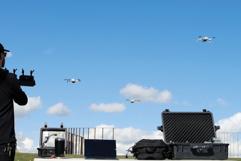
BETTER DATA WITH SWARMS
Threshold UAV aims to make farming more efficient with the powerful potential of drone swarm technology. This Alberta-based tech startup plans to deliver on-demand aerial data that is cost effective, in part through its control system that allows multiple drones to be flown simultaneously.
CEO Mac Hunik ventured into the agricultural technology space when he noticed limitations in research data gathered by single, thermal-sensor-equipped drones. It’s a problem he said also applies to other types of drone imagery. “We’re calling this a time–data collection problem,” he said. “One example is a drone will fly one way down the field to take photos, stopping at the end of the field to turn around, and as it’s doing so, a cloud comes overhead and changes the light conditions on the ground. As the drone flies the line back the other way, the images just captured won’t match up with the images captured from the first line.”
This is where drone swarm technology comes in to refine the data-gathering process. As AI and machine learning become more integrated within drone operation systems, swarm technology will allow comparable imagery to be captured and used as an input. “By creating this high-resolution data, on-demand service, we’re going to provide comparable data that will allow AI to progress faster in farming than it is currently,” said Hunik.
To put this technology to work Threshold UAV has teamed up with international AI companies and Alberta drone service providers to help farmers locate and remove rocks from their fields and negate equipment damage. By leveraging drone swarms and machine learning, farmers can efficiently identify, locate and check off the rocks as they are removed.
“The farmers we spoke to told us they don’t have access to the same type of labour that they used to because there are fewer kids on farms and the cost of labour has gone up,” said Hunik.
Now in the development and testing phase, the system allows a drone service provider to capture imagery of a field and create an interactive rock map the farmer can then use. A swarm of low flying drones is significantly more accurate than a single drone, said Hunik. “The rock map uses GPS services on the device to show the farmer, or picker, the fastest path to pick the rocks and checks them off as you go.
You know that the whole job is complete, and you can walk away and call it a night.” Hunik hopes to launch the Threshold rock mapping service soon. In collaboration with research and educational institutes, the company is now exploring additional applications for its drone control technology that include weed mapping, prescription mapping and swarm drone spraying.
In July, the Pest Management Regulatory Agency approved drone application of Corteva’s Carlon XRT, a non-agricultural vegetation management product. It is Canada’s first such approval.


Comments